Borders are supposed to be clean lines on a map. Straightforward. Sensible. Boring. But the planet is full of places where nations overlap, glitch, and fold into each other like someone rage‑quit halfway through drawing them. These are not your typical “take a pic at the sign and leave” border crossings. These are places where GPS gets confused, sovereignty is a suggestion, and your passport suddenly feels like improv theater.
This is extreme travel without the bungee cord — it’s you, your curiosity, and the thin, weird line that decides which laws you’re breaking. If you’re tired of safe, digestible destinations, step into the in‑between zones where nobody’s really in charge and everything feels a little bit illegal, even when it’s not.
The Village That Accidentally Swapped Countries (Haparanda‑Tornio, Sweden–Finland)
On paper, Haparanda (Sweden) and Tornio (Finland) are two different towns in two different countries. On the ground, they’re a single urban sprawl that acts like borders were a bad dream someone had in 1918. Walk down the street and your phone keeps switching time zones. Order a coffee in one country, drink it in another, and discover you might technically be late and early for your own life at the same time.
Extreme travelers come here not for thrill rides, but for the surreal sensation of drifting between nations without resistance. No dramatic checkpoints, no heavy fences — just bike paths, supermarkets, and a casual, quiet erasure of the idea that a line on a map should control your movement. In winter, the frozen river between them looks like a natural highway, and locals ski or walk across it like it’s a parking lot. You can design your own cross‑border ultra‑micro‑expedition: start in Sweden, buy snacks in Finland, return with them like a low‑budget smuggler for absolutely no reason but the story. It’s not adrenaline that hits you here — it’s the unsettling realization of how fake borders can feel when everything and everyone ignores them.
The Country Inside a Country Inside a Story (Lesotho’s Drakensberg Edge, South Africa–Lesotho)
Lesotho is a mountain kingdom completely surrounded by South Africa, like someone tried to delete it and the mountains refused. The extreme line here isn’t just political — it’s vertical. When you approach the Drakensberg escarpment and the Sani Pass that leads into Lesotho, it feels like you’re driving off the edge of the world and hoping it grows a staircase just in time.
This is where overland obsessives and border chasers roll the dice on weather, altitude, and sketchy switchbacks. Your journey shifts from paved boredom to loose gravel and hairpin turns that seem designed by a drunk goat. At the top, you cross into Lesotho via a tiny, wind‑gnawed border post that feels like a checkpoint between realities. Suddenly you’re in village‑dotted highlands where shepherds wrapped in blankets watch your 4x4 like it’s an alien animal. For an extreme traveler, the thrill isn’t danger for its own sake — it’s that moment when your altimeter goes up, your speed goes down, and you realize this border crossing is less about immigration and more about ascending into someone else’s idea of what a country can be.
The Airport That Lives in Two Nations at Once (Basel–Mulhouse–Freiburg)
Basel–Mulhouse–Freiburg Airport is what happens when three countries — France, Switzerland, and Germany — decide to share a building and pretend that’s normal. Technically located in France, connected by a special customs corridor to Switzerland, and serving a German city by name, this airport is the spatial equivalent of a diplomatic inside joke. Your boarding pass, your language, and your SIM card may all be wrong simultaneously.
Extreme travel here looks like a self‑directed sovereignty puzzle. You land “in France,” exit into “Switzerland” without going through France at all, then hop a bus that takes you to Germany — all without ever feeling like you truly entered any of them in a clean narrative way. For border freaks, this place is a sandbox: plan a route that hits three countries in under an hour without a single dramatic landscape change, only shifting sets of rules and currencies. Watching uniformed officers share hallways yet guard invisible lines in the same building hits that sweet, disorienting note: you’re safe, but the logic of territory clearly isn’t.
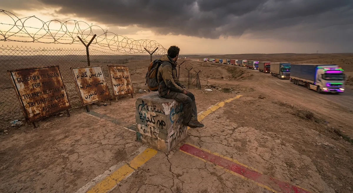
The Four‑Corner Illusion vs. the Real Edge Crossings (US Desert Borderlands)
There’s the tourist trap: Four Corners, where you can pay to stick a limb in four US states and grab a photo. That’s border cosplay. The real extreme travel lies further south and west, in the US desert borderlands where the line between countries becomes a character: unpredictable, moody, and occasionally lethal. Out here between the US and Mexico, or out near the almost‑forgotten corners of New Mexico and Texas, the map is clean but the reality is not.
You’ll find dirt roads that become legal questions, fence lines that end abruptly in open scrub, and patrol trucks materializing out of heat haze like boss fights. This isn’t tourism to be taken lightly — it demands respect, research, and local knowledge. The thrill isn’t “ooh, danger” so much as the heavy awareness that you’re moving through a live fault line of policy, politics, and survival. If you hike, you might see sensors half‑buried in sand; if you camp, you might catch the distant glare of watchtowers. It’s an extreme form of border travel because the line isn’t just on a map — it’s in every decision you make about how far you walk and how well you understand where you are not supposed to be.
The River That Forgets Which Side Is Which (Rio Quaraí, Brazil–Uruguay)
On the border between Brazil and Uruguay, the Rio Quaraí (Cuareim) has one job: separate two countries. Instead, like every river ever, it meanders, shifts, floods, and changes course. The map doesn’t always keep up. The result: pockets of land that one side thinks are theirs, the other side gently disagrees about, and locals quietly farm anyway. It’s not a war zone; it’s a polite cartographic headache.
For extreme travelers, this isn’t about danger — it’s about subtle dislocation. Imagine standing on a grassy riverbank, watching cattle graze on land that might technically belong to the other country depending on which year’s survey you believe. Paint fades on old border markers. Fences sag. A fisherman waves at you from the “other side,” then later walks up to the same café as you in town because the “sides” aren’t how real life works here. Traveling this frontier means chasing the edges of sovereignty where nobody seems eager to enforce the rules too hard. It’s a slow, gentle kind of extremity: not cliffs and storms, but the unsettling freedom of places where nobody is counting your footsteps across the imaginary line.
Conclusion
Extreme travel doesn’t always mean hanging from a rope or clinging to the side of a volcano. Sometimes the real drop is psychological: stepping into spaces where borders are flexible, shared, ignored, or hilariously overcomplicated. These are the fault lines where nations glitch and everyday life just carries on.
If you’re hungry for trips that feel “no way” without needing a helmet and waiver, follow the lines on the map — then go find all the places where reality refuses to match. That’s the frontier now.
Key Takeaway
The most important thing to remember from this article is that this information can change how you think about Extreme Travel.


